日本語 日本語のサイトはこちらをクリックしてください
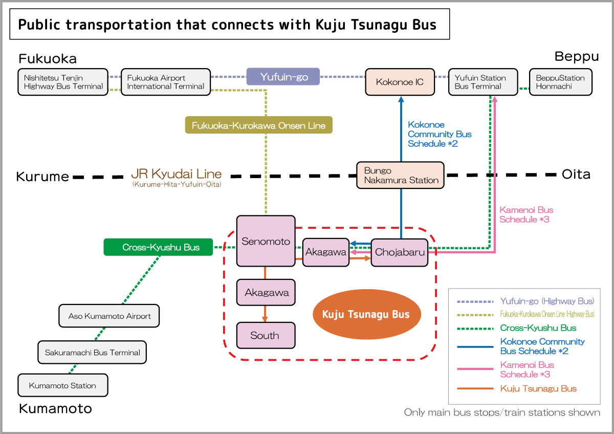
What is the Kuju Tsunagu Bus?
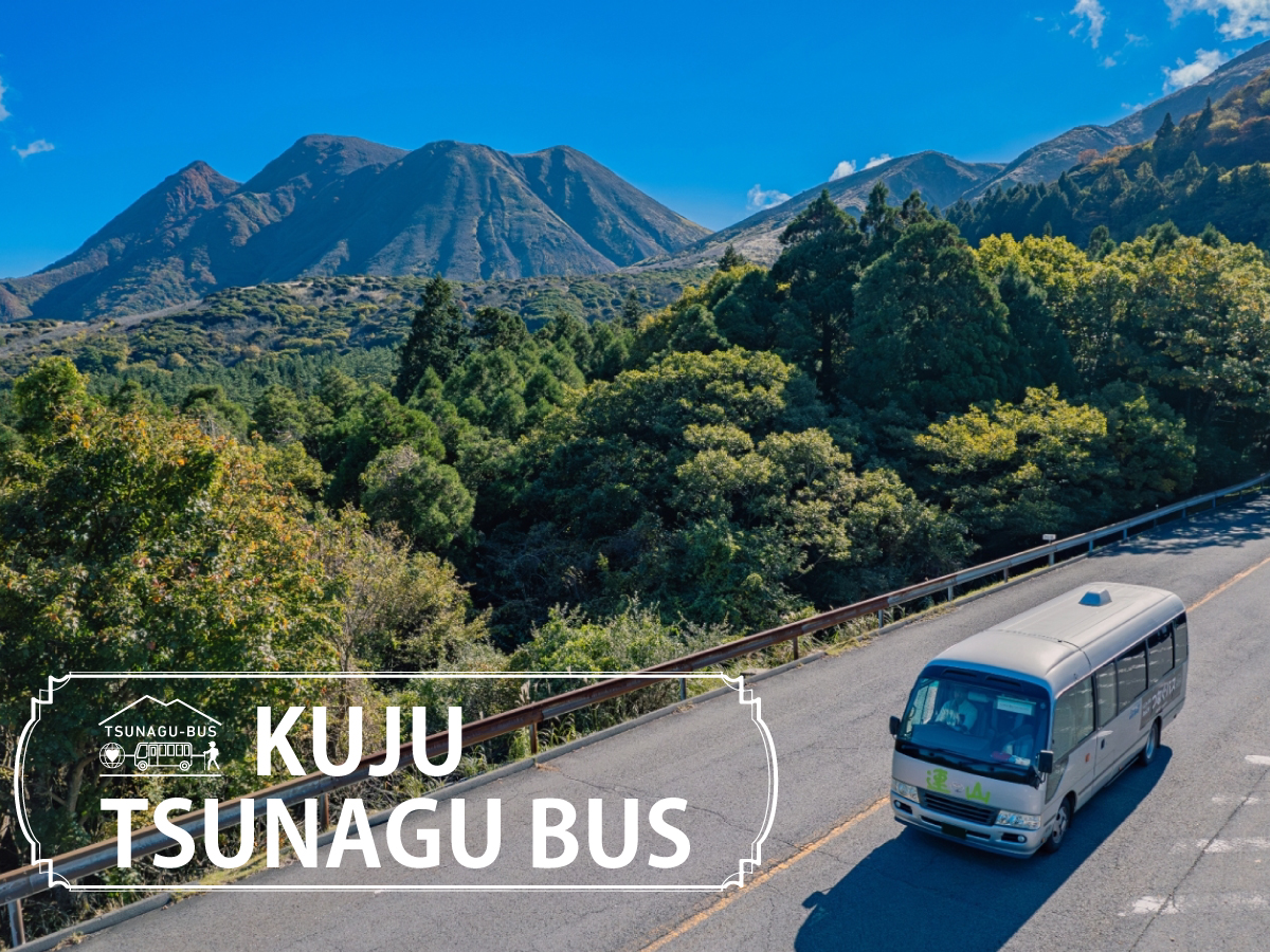
The Kuju Tsunagu Bus is operated by Sherpa Co., Ltd. and Yama no Tabi Kikaku-shitsu Co., Ltd. with the cooperation of administrative organizations in the Kuju area and the Ministry of the Environment, which is promoting the Project to fully Enjoy National Parks for the conservation and utilization of Oita Prefecture and Aso Kuju National Park.
〈Contents〉
● Street Parking & Crowding during Peak Periods
1. Street parking during peak periods
2. Crowding on trails during peak periods
3. Goals of Kuju Tsunagu Bus
● Appeal of Point-to-Point Hikes in Kuju
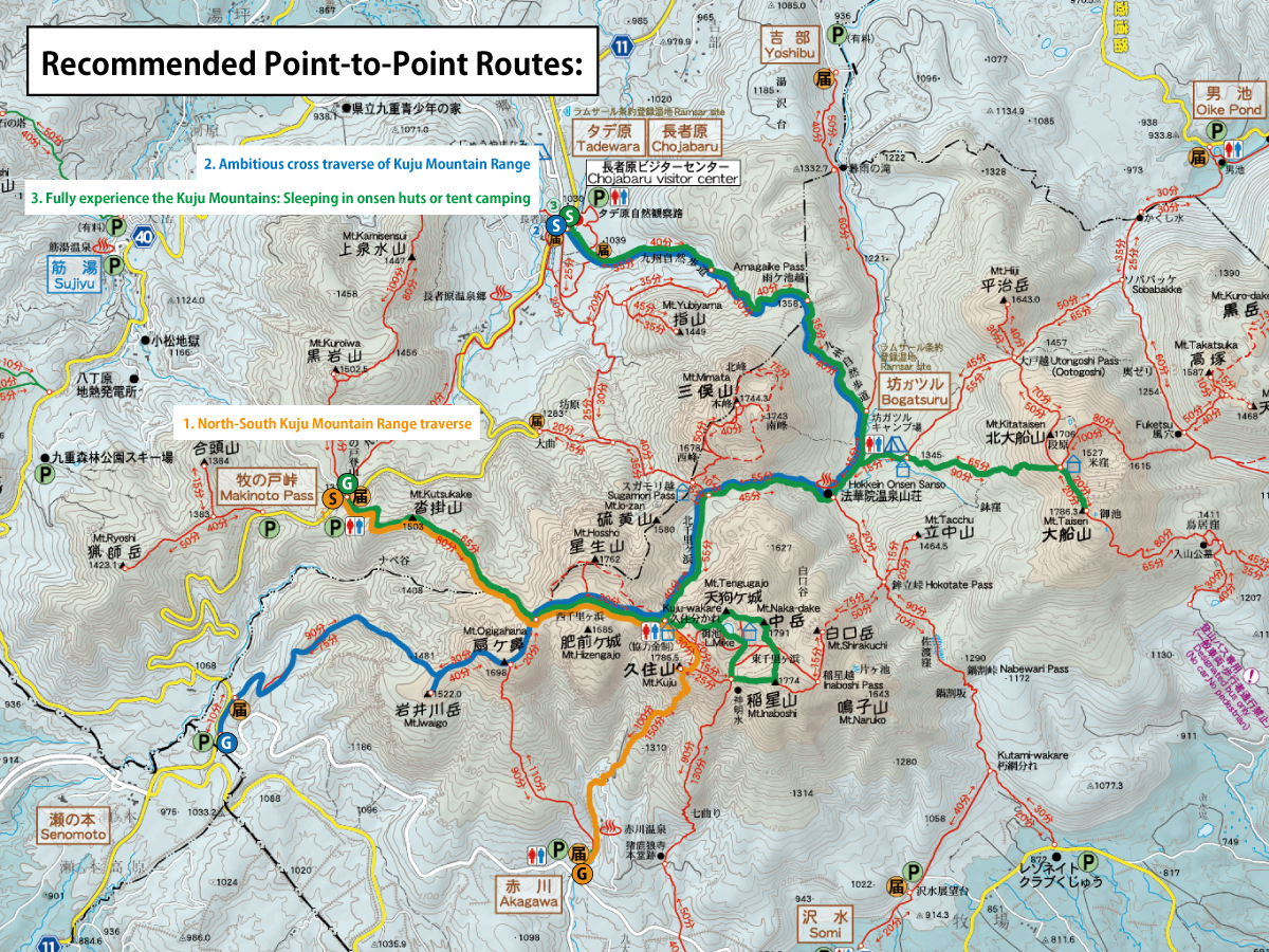
1. North-South Kuju Mountain Range traverse
2. Ambitious cross traverse of Kuju Mountain Range
3. Fully Experience the Kuju Mountains: Sleeping in onsen huts or tent camping
● Parking (parking available only during Kuju Tsunagu Bus operating periods)
1. Street parking during peak periods
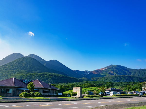
Due to the popularity of the Kuju Mountains, trailhead parking lots have a tendency to become full and it can be hard to find parking. This is especially true when Miyama Kirishima bloom or during the autumn foliage season, leading to congestion and parking lots filling up early in the morning. Vehicles unable to use the parking lots park on the roadside, particularly around Makinoto Pass, obstructing tourist buses and large vehicles and making it difficult for them to pass each other. This issue diminishes the enjoyment of the hiking experience.
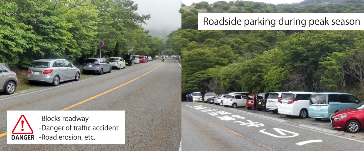
Roadside parking leads to a variety of problems
2. Crowding on trails during peak periods
Many Kuju hikers use either the Makinoto Pass or Chojabaru trailheads. A large number of hikers visit the trails during the short peak season, leading to soil erosion and muddy conditions. Additionally, to avoid newly muddy areas, the trails become dual-tracked, raising concerns about environmental impact due to overuse.
Chojabaru Trailhead
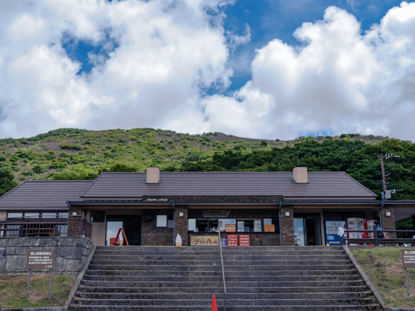
Makinoto Pass Trailhead
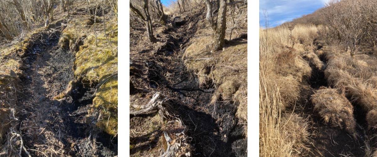
Double-tracking and hiking trails with eroded soil
3. Goals of Kuju Tsunagu Bus
The Kuju Tsunagu Bus was launched in the fall of 2022 to reduce these problems. The goal is to optimize conditions to prevent the overcrowded of specific parking lots and trails by connecting the Chojabaru and Senomoto parking lots with the main trailheads via a shuttle bus, thereby enhancing user satisfaction and protecting the environment of Aso-Kuju National Park. Additionally, visitors can use the bus for point-to-point hikes, which increases the variety of hiking options available.
Main Trailheads:
- Chojabaru Trailhead
- Makinoto Pass Trailhead
- Senomoto Trailhead
- Akagawa Trailhead
- South Trailhead
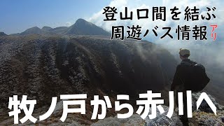
Kuju Tsunagu Bus - Connecting the Trailheads of the Kuju Mountains(Japanese only)
Click here for more details on the Kuju Tsunagu Bus
The Kuju Mountain Range features a series of mountains including Nakadake, the highest peak on the Kyushu mainland (1,791 meters), as well as other peaks around 1,700 meters. The area is rich in alpine vegetation, such as the Miyama Kirishima Rhododendron kiusianum, and boasts numerous attractions like the Tadewara Marsh and the Bogatsuru Marsh, which were registered as Ramsar Convention Wetlands in 2005. The landscape changes with the seasons, and with multiple trailheads available, there are various routes to enjoy the Kuju Mountain Range. The following are three point-to-point routes we recommend based on:
- Ease of access from both Oita and Kumamoto Prefectures
- Easy manageable hiking time and elevation changes for all levels of hikers including beginners
- You can see the scenery of almost the entire Kuju Mountain Range, and the valuable natural environment.
In Kuju Mountains, there are manners to follow when hiking. Be prepared to equip yourself properly and check in advance to ensure an enjoyable hike.
Rules & Manners for Hiking Kuju
https://kujufanclub.com/walk/#rule(japanese only)
Point-to-Point Route #1:
North-South Kuju Mountain Range traverse
Details:
Makinoto Pass Trailhead ⇒ Mt. Kutsukake ⇒ Ogigahana (round trip) ⇒ Nishi Senrigahama ⇒ Mt. Kuju ⇒ Akakawa Trailhead
Time:
265 min (4hr 25min)
Difficulty:
Low technical difficulty, but caution is required as the descent has continuous steep sections
Route overview:
This is a popular course that includes Mt. Kuju, the main peak of the Kuju Mountain Range. Starting from the Makinoto Pass trailhead (1,330m), the highest altitude trailhead, makes it relatively easy to walk. Proceed along the well-maintained trail to the first peak, Mt. Kutsukake. Continue along the trail and aim for Mt. Ogigahana from the Ogigahana junction. Near the summit, there is a colony of Miyama Kirishima. During the blooming season of May and June, the view is spectacular.
Upon reaching Mt. Ogigahana, return the way you came to the Ogigahana junction. Then proceed to Nishi Senrigahama, walking along a trail with minimal differences in elevation while viewing Hizengajo on your right and Mt. Hossho on your left.
After crossing the large rocks of Hosshozaki, you will arrive at the Kuju Wakare emergency hut. You can take a break inside the hut, which is equipped with a toilet booth and a portable toilet booth, making it convenient for women and small children.
From the summit of Mt. Kuju, you can see the Five Peaks of Aso, and enjoy a 360-degree panoramic view of Yufudake (Oita Prefecture), the Hikosan Range (Fukuoka Prefecture), the Tara Range (Nagasaki Prefecture), and the Kirishima Mountain Range (Kagoshima and Miyazaki Prefectures). On the descent, enjoy the scenery of the Kuju Plateau as you descend to the Akagawa trailhead.
Point-to-Point Route #2
Ambitious cross traverse of Kuju Mountain Range
Details:
Senomoto Trailhead ⇒ Iwaigawadake ⇒ Ogigahana ⇒ Nishi Senrigahama ⇒ Mt. Kuju ⇒ Kuju Junction ⇒ Kita Senrigahama ⇒ Bogatsuru ⇒ Amagaike Pass ⇒ Chojabaru Trailhead
Time:
455min (7hr 35min)
Difficulty:
The long hours of mountain walking requires strong legs. Not technically difficult, but caution is needed as you will be descending a long, rocky ridge.
Route overview
Starting from the Senomoto trailhead, you will climb to Iwaigawadake and Ogigahana. Since the Senomoto trailhead is less than 1,000 meters in elevation, you can enjoy the rare experience of walking through the forest until you reach the tree line of the Kuju Mountains (1,400 meters).
Stop at the Kuju Wakare emergency shelter and walk along the western rocky slope of Mt. Kuju to the summit, where you can enjoy a 360-degree panoramic view of the major mountains of mainland Kyushu. If your pace allows, you might want to take a 40-minute detour to Nakadake, the highest peak on mainland Kyushu. After returning to Kuju Wakare, you will descend to Kita Senrigahama, where you can walk on volcanic ash that resembles the surface of the moon.
Upon arriving at Hokkein Onsen Sanso, take a break in the lounge or enjoy some light snacks. The descent will take you via Amagaike Pass to Chojabaru, the northern gateway to the Kuju Mountains. There are shops and eateries where you can satisfy your hunger and enjoy some shopping.
Point-to-Point Route #3
Fully Experience the Kuju Mountains: Sleeping in onsen huts or tent camping
Details:
Day 1:
Chojabaru Trailhead ⇒ Amagaike Pass ⇒ Bogatsuru ⇒ Mt. Kitataisen ⇒ Mt. Taisen ⇒ Bogatsuru ⇒ Sleep at Hokein Onsen Sanso (or in tent at Bogatsuru)
Day 2: Hokkein Onsen Sanso (Bogatsuru) ⇒ Kita Senrigahama ⇒ Tengugajo ⇒ Nakadake ⇒ Mt. Inaboshi ⇒ Oike ⇒ Kuju Wakare ⇒ Kuju Mountain ⇒ Kuju Wakare ⇒ Nishi Senrigahama ⇒ Mt. Kutsukake ⇒ Makinoto Pass Trailhead ⇒ Kuju Tsunagu Bus to Chojabaru Trailhead
Time:
760min (Day 1: 400min [6hr 40min], Day 2: 360min [6hr])
Difficulty:
Not technically difficult, but long walking times require stamina.
Route overview:
The course starts from the Chojabaru trailhead, passing through the Tadewara Wetlands. After passing through Amagaike Pass (June: yamarakkyo clusters), you arrive at Bogatsuru, where the mountain you aim to climb will appear before you. At Mt. Taisen and Mt. Kitataisen, you can see clusters of Miyama Kirishima that dye the mountain slopes pink from late May to June. At Hokkein Onsen Sanso, enjoy local cuisine, hot springs, and a starry sky.
The next day, wake up early and aim for Nakadake, the highest peak of the Kuju Mountain Range, via Tengugajo. Watching the sunrise from the summit will blow away your fatigue and lift your spirits. In the latter half, extend your journey to Mt. Inaboshi, then walk along Oike and climb Mt. Kuju while looking back on the mountains you traversed.
For the descent, head from Kuju Wakare to Nishi Senrigahama, then descend to the Makinoto Pass Trailhead via Mt. Kutsukake. This route gives you the full Kuju Mountain Range experience.
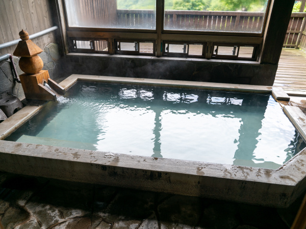
Visitors can use the baths at Hokkein Onsen without staying the night
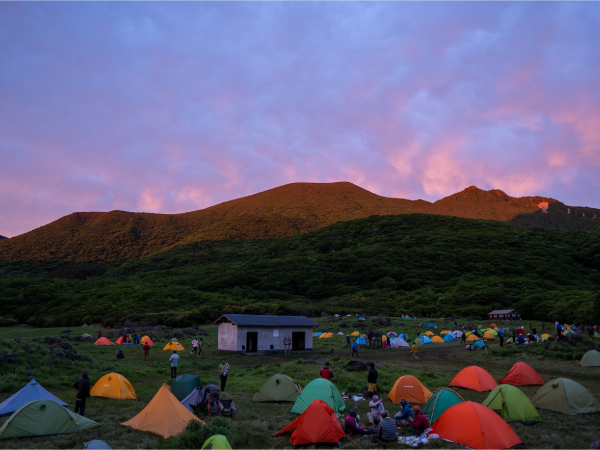
Lots of hikers camping at Bogatsuru
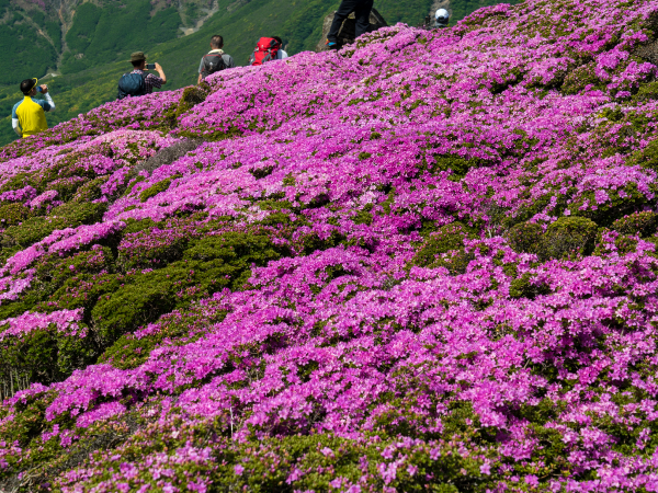
Miyama Kirishima on the slopes of Hiijidake
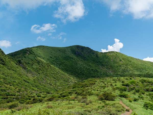
Mt. Hossho enveloped in lush greenery
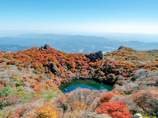
Oike Pond at the summit of Mt. Taisen
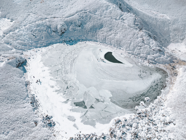
You can walk on frozen Oike Pond.

When using the Kuju Tsunagu Bus, please park your car in the parking area designated for riders on the Kuju Tsunagu Bus. For details on locations and more, go to "Click here for more details on the Kuju Tsunagu Bus" below.
The specific Kuju Tsunagu Bus parking is only available when the bus is in operation. These divided parking lots are not available during non-operation periods.
Parking can also be used for carpooling.
At bus operating times, the Senomoto parking lot could be fully parked except divided parking only for Kuju Tsunagaru Bus users.
Do not park on the street under any circumstances.
Do not park in parking lots for stores or other facilities.
From Fukuoka:
Hakata Bus Terminal ⇔ Yufuin Station Bus Center: Approximately 2 hours
Yufuin Station Bus Center ⇔ Makinoto Pass Trailhead: Approximately 1 hour
From Oita:
JR Beppu Station ⇔ Makinoto Pass Trailhead: Approximately 2 hours
From Kumamoto:
Kumamoto Station ⇔ Makinoto Pass: Approximately 2.5 hours
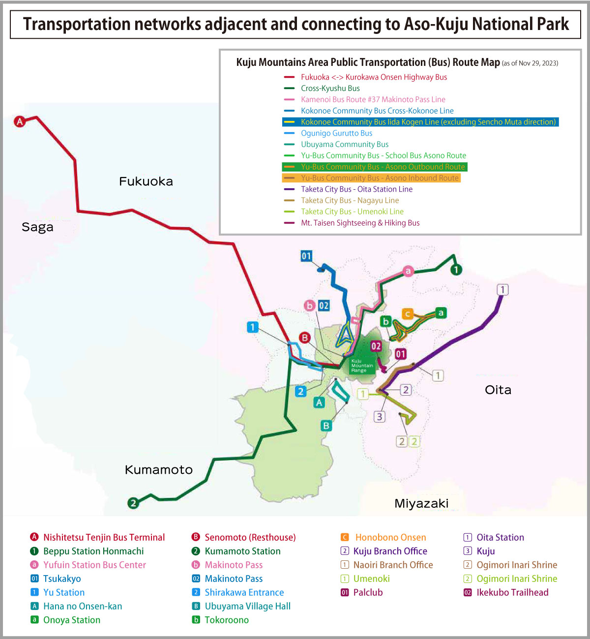
Bus Companies:
-Yufuin-go: Nishitetsu, Kamenoi Bus, Kyushu Sanko Bus
-Fukuoka-Kurokawa Onsen: Kyushu Sanko Bus, Hita Bus
-Cross-Kyushu Bus: Kyushu Sanko Bus
-Kokonoe Community Bus: Kokonoe
Public Transportation Websites:
Nishitestsu https://www.nishitetsu.jp/bus/highwaybus/
Kamenoi Bus https://kamenoibus.com/
Kyushu Sanko Bus https://www.sankobus.jp/
Hita Bus https://hitabus.com/
Kokonoe Community Bus https://www.town.kokonoe.oita.jp/docs/2018091900022/
-@Bus De: Kyushu Bus Network Portal Site: https://www.atbus-de.com/
-JR Kyushu https://www.jrkyushu.co.jp/
1. Chojabaru Visitor Center
This facility introduces the nature and culture of the Tadewara Wetlands and the Kuju Mountain Range. Inside the center, you can enjoy high-definition theater videos of the four seasons of Kuju, as well as view large satellite photos of the Aso-Kuju area.
https://kujufanclub.com/(Japanese only)
2. Hokkein Onsen Sanso
The only mountain hut in the Kuju Mountain Range. Located at an altitude of 1,303 meters, it is popular among many hikers. It once flourished as the Mt. Kuju Hokkein Hakusuiji Temple founded in the Kamakura period (1185-1333) and began its history as a mountain lodge in 1882. Visitors can also stop by just for the hot springs or meals.
http://hokkein.co.jp/(Japanese only)